The 1952 parish account describes Barnhill, Hunthill and Kirkton as the principal High Blantyre districts before industrial expansion. It recalls traditional stone-and-lime houses, many thatched, while acknowledging that few survived by the account's date. The account reflects local historical memory and does not provide a building-by-building inventory. Third Statistical Account, 1952
High Blantyre's role as parish centre connects its church and school history to the wider settlement geography. Late nineteenth-century census analysis grouped Auchinraith within High Blantyre for some statistical purposes, which should not be mistaken for a timeless definition of the locality. See Blantyre settlement geographies in 1891 mining research and The historical parish of Blantyre.
Main Street in 2014
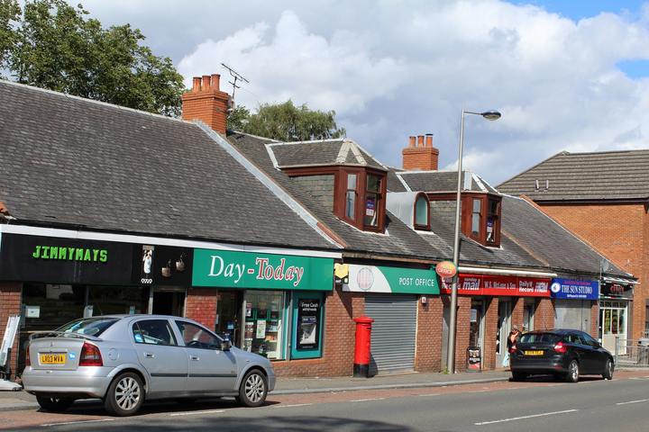

This photograph provides a dated view of the village’s commercial centre and its shop frontage. It records the street on the day of capture rather than its historical appearance. leslie barrie main street high blantyre photo
Kirkton in the mid-nineteenth century
Lewis’s 1846 village entry calls the parish-centre settlement “Blantyre, or Kirkton” and reports 264 inhabitants, placing it on an eminence above the Clyde and about three miles from Hamilton. This is a village count within the much larger parish and must not be confused with the Low Blantyre mill population. The gazetteer also records a parish church erected in 1793, described as in poor repair and able to hold about 300. This is a period snapshot; later church rebuilding and population growth are covered separately. lewis topographical dictionary blantyre 1846 Blantyre population, 1755–1951 Lewis, 1846
Barnhill is a distinct historic village close to, but not identical with, Kirkton. Lewis’s 1846 account places it half a mile north of Blantyre and gives 165 residents; the later Naismith directory places a tavern, farm and blacksmith there. Its settlement history is set out separately in Barnhill, Blantyre. Samuel Lewis, Topographical Dictionary of Scotland: Blantyre (1846)
Civic centre and parish institutions
High Blantyre’s role as the old parish centre also made it a focus for local administration. Late nineteenth-century sources describe the parish poor-law authority and later parish council in the wider Blantyre administrative framework; a local retrospective dates the council’s purpose-built Cemetery Road chambers to 1901. A 1909 School Board meeting is reported to have taken place there while members considered additional school capacity. These reports link the village’s civic buildings to education and welfare, but the chambers’ exact site, design, construction account and demolition sequence still require valuation rolls, plans and original press or minute-book checks. Blantyre local government history Blantyre School Board
Archer’s Croft and reported burials
Nineteenth-century accounts place more than one burial discovery in the historic High Blantyre landscape, but their findspots should not be merged. The New Statistical Account, written around 1835, says a cist with an urn and human remains was found “about three years ago” at Shott, near the parish church; it separately places fragments of six larger urns in other parts of the field called “Arches or Archer’s Croft”. A later planning statement, summarising WoSAS evidence and citing the 1858 Ordnance Survey Name Book, assigns a cist with urn and inhumation to Archer’s Croft in 1826 and gives 1826 and 1842 as find dates. Until the Name Book and underlying records are checked, the discrepancy remains open: the account may describe separate events, or later summaries may have conflated a Shott cist with the Archer’s Croft urn fragments. A distinct 1939 cist was discovered at Coatshill Farm, well away from these church-side fields. New Statistical Account, pp. 320–21 · Malcolmwood planning statement Prehistoric and archaeological sites of Blantyre malcolmwood farm bess planning statement
Main Street in early photographs
Local photographs provide views of Main Street around Kirkton Cross before and between the world wars. A Blantyre Project caption dates one westward view to 1904 and identifies McKenzies’ bakery, a small single-storey building it dates to 1823, and Speirs’ laundry; the underlying photograph, building identity and construction date remain unverified against deeds, directories or maps. A second caption dates a view from Priestfield looking east towards Hamilton to 1927 and identifies the co-operative store, other shops and a garage near Broompark Road. The paired captions suggest commercial streetscape change, but without matching the image locations to historic maps they are evidence of attributed views rather than a complete building chronology. Reuse rights remain unclear, so neither photograph is reproduced here. blantyre project high blantyre main street 1904 blantyre project high blantyre main street 1927 1904 photograph record · 1927 photograph record
Related
- Blantyre Kirk Session and parish church records
- Churches, schools and societies in Blantyre in 1879
- ordnance gazetteer blantyre 1885
- third statistical account blantyre 1952
- Low Blantyre and the Works village
- Blantyre, South Lanarkshire