Glasgow Road in town-centre planning
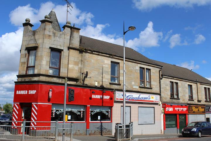
South Lanarkshire Council’s 2022 town-centre strategy identifies Glasgow Road as the core retail area and as an A-class route linking Hamilton and Cambuslang, with onward access to the East Kilbride Expressway and M74. The strategy map draws a town-centre boundary around facilities and paths to the railway station; this is the plan’s study area rather than proof of a legal town boundary. The 2018 Your Town Audit, as summarised in the strategy, reported that 70 per cent of retailers were independent and that half of the businesses served the evening rather than daytime economy. These dated counts should not be projected onto the present street without a new audit. South Lanarkshire Council strategy, pp. 2–4 (South Lanarkshire Council: Blantyre Town Centre Strategy and Action Plan) Blantyre Town Centre Strategy
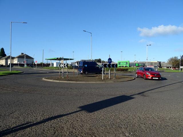
The strategy records 2019 redevelopment around Clydeview Shopping Centre and the ASDA store, petrol station and adjoining car park. It says vacant retail and office units on Glasgow Road were demolished for replacement by modern units, but the passage is a planning-era statement and does not establish the later completion or occupancy of every unit. It also lists a Costa Coffee drive-through consent dated 6 June 2019 as a proposed addition to daytime activity. The strategy records proposals and consents, not the later completion or occupancy of every unit. Council strategy, pp. 3–4 (South Lanarkshire Council: Blantyre Town Centre Strategy and Action Plan)
Route and early landscape
A local Glasgow Road history describes the route as medieval, but the sources cited here do not establish that precise origin. Historical mapping shows a long-established corridor between the parish’s settlement areas. NLS confirms the availability of digitised high-resolution historical maps and gazetteers, while the OldMapsOnline catalogue identifies the National Library of Scotland’s Ordnance Survey Lanark Sheet XI.10 Blantyre 25-inch series as surveyed in 1859 and published in 1864.
Paul Veverka’s account describes the road in 1859 as predominantly rural between the Burnbank boundary and Stonefield Road, naming Springwell House, Stonefield Farm, the Winks Inn, a tollhouse and a few scattered properties. A separate Springwell article says the farm stood at the junction with the track that became Auchinraith Road and that its field landscape was later built over. This reconstruction is useful for orientation, but the precise location and date of every named property are not independently established here. Glasgow Road chronology · Birth of Springwell
Industrial growth and urban street
Coal extraction and the arrival of workers changed the corridor from separated farms and hamlets into a linear town street. The local account associates later nineteenth-century growth with miners’ housing, shops, side streets and institutions, and describes Glasgow Road as densely built by the end of the 1890s. This street-level growth formed part of the wider parish population expansion documented in Blantyre population, 1755–1951. Blantyre Colliery Blantyre population, 1755–1951 Stonefield, Blantyre
The street became an institutional centre as settlement expanded. Historic sites on or close to it include Stonefield Parish School, St Joseph’s Catholic Church and School, Livingstone Memorial Church and the Burleigh/Anderson congregational history. The 1879 directory supplies a contemporary snapshot of schools, churches and societies, while school histories describe subsequent buildings and closures. This makes Glasgow Road a useful organising geography for the histories of education, religious provision and community services, rather than a street chronology detached from its residents. Churches, schools and societies in Blantyre in 1879 Stonefield Parish School St Joseph’s Catholic Church, Blantyre Livingstone Memorial Church, Blantyre St Andrew’s Parish Church, Blantyre
Retail co-operation and central premises
The corridor also concentrated co-operative retail. Blantyre Project reports that the local Society opened its first shop on Station Road in 1883, then rented premises at Henderson’s Building on Glasgow Road. It later expanded at Avon Buildings, added rear stores and stables, and established committee rooms before building its central hall and offices at Herbertson Street.
The 1952 Statistical Account independently described the Society as having a very large membership and commodious premises at Station Road, Glasgow Road, Auchinraith Road and Main Street. Local sources identify the central hall as Herbertson Street and report film screenings there, illustrating how retail infrastructure also supported assembly and leisure. The place-name/address distinction is not resolved in the contemporary account. third statistical account blantyre 1952 Cinemas in Blantyre
Tramway and road widening
Electric trams reached Blantyre in July 1903 as part of the Hamilton, Motherwell and Wishaw system. The line initially ended near Stonefield Road; construction westwards towards Priory Bridge is reported from May 1906. The local account dates passenger opening towards Cambuslang to 20 January 1907, while the specialist network chronology gives 20 June; Summerlee says the extension was completed in 1906, which may describe construction rather than passenger service. These sources have not resolved whether all dates refer to the same milestone, so the opening date remains contested under UC-067. Both local and specialist sources describe a change at Priory Bridge rather than through-running onto Glasgow Corporation’s network. Blantyre tramways summerlee lanarkshire tramways history Specialist system chronology · London Transport Museum catalogue
Trams altered both access and the physical road. The local account describes track construction, granite setts and named stopping points, and places a passing loop near Coatshill. It reports a suspension of the Blantyre–Cambuslang service on 10 May 1929 as road widening work began; this is best treated as a temporary interruption associated with works, because the same transport account dates the end of Blantyre tram service to 6 October 1930. Tram removal and garden loss reportedly affected properties and public buildings including St Joseph’s, Livingstone Memorial Church and Low Blantyre School.
Bus travel and the modern corridor
Bus transport now forms another layer of Glasgow Road’s history. The Leyland Society independently documents a Glasgow–Hamilton service operated by William Baxter by 1924 and its takeover by J. W. & R. Torrance in 1929. A local indexed account reports a High-to-Low Blantyre route via Stonefield Road from January 1929 and 36 buses passing Glasgow Road in one morning hour in October 1930; these are figures reported by the local chronology and should be read as period-specific observations. The 1952 parish account described the road as well served by motor omnibuses. First Bus’s service 263 timetable, stated as valid from June 2025 until further notice, lists stops at the industrial estate, High Blantyre Cross, Stonefield Road and West End. These sources belong to different periods and do not establish uninterrupted route continuity or a passenger trend. Bus services in Blantyre blantyre project buses indexed excerpt Leyland Society, Torque 17 · First Bus service 263
Traffic and air-quality monitoring
Glasgow Road has also been the focus of roadside NO₂ monitoring. Ricardo’s 2020 detailed assessment modelled 2019 concentrations at pedestrian and residential receptors using traffic, monitoring and meteorological inputs. It predicted 40.8 µg/m³ only at a selected first-floor receptor under a site-specific “worst-case” adjustment; the domain-wide adjustment gave 37.7. The Council did not consider this uncertain, localised result sufficient to confirm an AQMA. An independent Environmental Standards Scotland report separately records a 2020 diffusion-tube result of 46 µg/m³ at 233 Glasgow Road. A later twelve-month Council study reported NO₂ and particulate measurements below their stated annual objectives, and Defra accepted the study conclusions while recommending continued monitoring. Separately, the national roadside automatic station SLC09 recorded annual NO₂ means of 18.2 µg/m³ in 2023 and 16.8 µg/m³ in 2024, with data capture above 99% both years. These results describe different methods, years and exposure locations; none is a single summary value for the whole road. Air quality monitoring in Blantyre ricardo repeat detailed assessment blantyre 2020 south lanarkshire air quality apr 2024 scottish air quality blantyre site profile saqd annual report blantyre 2023 saqd annual report blantyre 2024
Street and landscape change
Historical maps trace the transition from fields and separate settlements to a built corridor. Blantyre Project’s map archive includes 1897–98 sheets depicting streets, railway routes, hamlets and industrial features, which can be read alongside the Ordnance Survey sequence. blantyre project mapping index historical maps
Recent street views


Related
- Blantyre tramways
- Springwell, Blantyre
- Stonefield, Blantyre
- Low Blantyre and the Works village
- historical maps
- blantyre project glasgow road history