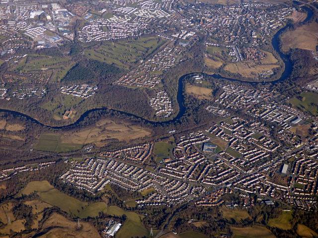
Blantyre and the Clyde from the air

Landscape and settlement
The nineteenth-century gazetteer places the River Clyde along the parish’s north-eastern margin and the Rotten Calder on much of its western side, with land rising southwards from the river corridor. It distinguishes Blantyre village—also called High Blantyre or Kirkton—from Blantyre Works, known as Low Blantyre, and names Auchinraith, Auchintibber, Barnhill and Stonefield as other parish localities. In 1846, Auchinraith was described separately as a hamlet with 77 inhabitants; later 1891 mining research also assigned it its own enumeration district. These are historical descriptive and research geographies, not precise modern neighbourhood borders. The historical parish of Blantyre Auchinraith, Blantyre provides the locality evidence and distinctions. Ordnance Gazetteer · Lewis, 1846
Town setting and council planning geography
A separate municipal description in the 2022 town-centre strategy places Blantyre between the Clyde, Rotten Calder, Park Burn and Rotten Burn. It presents these as town-setting features; its red-dashed town-centre map is a strategy boundary around selected retail and civic amenities, not a legal boundary of Blantyre or a replacement for the historic parish geography. The strategy describes Glasgow Road as the core retail area, with the railway station and David Livingstone Centre within walking distance, and identifies bus and rail links to Hamilton, Glasgow and wider South Lanarkshire. Blantyre Town Centre Strategy Council strategy, pp. 2–3
Historical outline
The surviving remains of Blantyre Priory attest to a medieval monastic presence above the Clyde. HES places its foundation in the first half of the thirteenth century, its affiliation with Jedburgh Abbey, and a later conversion to a private residence after secularisation in 1599. The priory is one important strand in the area’s history, alongside its later agricultural and industrial communities. HES designation
Cotton manufacture reshaped the riverside. The New Statistical Account says a mill was erected in 1785 by David Dale and James Monteith, followed by another in 1791 and an expanded weaving factory by 1813. The works village included accommodation at Shuttle Row. David Livingstone and Blantyre was born there in 1813 and entered mill work as a child, linking family experience to the wider labour history of the settlement. New Statistical Account · Birthplace museum
Coal mining later brought major industrial employment, new housing and severe hazards. The 22 October 1877 explosion at Dixon’s connected Nos. 2 and 3 pits killed hundreds, but the exact total remains disputed among contemporary and later accounts. The inquiry ran for eleven days at Hamilton in November and the surviving account describes 48 witnesses; a contemporaneous mining journal’s 23 October dispatch estimated 233 underground, an early figure rather than a final toll. Further fatal events included the March 1878 overwinding accident and the July 1879 explosion at Blantyre Colliery; the latter’s final count is also unresolved. In 1930 a firedamp explosion at the separate Auchinraith Colliery killed six and injured eight according to the official report; later newspaper and local-history records disagree about one victim’s name and another man’s injury classification. The inspector’s detailed account documents mechanised longwall mining alongside failures and uncertainties in gas inspection, shot-firing practice and egress. These are distinct events with separate evidence and should not be collapsed into one disaster narrative. Auchinraith Colliery closed in August 1931; later accounts disagree whether more than 300 or more than 350 jobs were lost. Its plant sale in 1932 and Merry and Cuninghame’s liquidation, reported complete in 1936, trace an industrial transition beyond the disaster itself, though closure totals and the liquidation detail remain sourced to local retrospective and excerpt-level records. Auchinraith, Blantyre See Blantyre mining disaster of 1877, Blantyre Colliery overwinding accident of 1878, Blantyre Colliery explosion of 1879 and Auchinraith Colliery disaster of 1930. auchinraith mines department report 1931
Co-operative retail became another important part of the industrial town’s social economy. A contemporary 1952 parish account describes the Blantyre Co-operative Society as having a very large membership and premises across Station Road, Glasgow Road, Auchinraith Road and Main Street. Local histories trace its reported 1883 Station Road shop, later branches and bakery, halls, savings activity and a 1932 merger with Stonefield Independent Society before its own identity ended in 1972. The contemporary account confirms scale and geography; more detailed dates and addresses are attributed to retrospective local histories, while the 1952 account independently confirms the Society’s scale and distribution of premises. Blantyre Co-operative Society Third Statistical Account, p. 437 (Third Statistical Account: Parish of Blantyre (1952))
The RNLI’s published annual lists add a small but independently documented strand of institutional philanthropy: they record the Society at £2 annual subscription in 1909 and £2 donation in 1910. The sources do not explain whether either payment was raised locally or authorised through the membership. rnli blantyre cooperative contributions
The Clyde-side landscape now also preserves the physical evidence of industrial decline and environmental change. South Lanarkshire Council’s reserve management statement traces the area from farming and estate use, through a colliery and slag heap at Priory Bing visible into the late 1960s, to a modern woodland, grassland and riverside path network. Redlees similarly combines evidence of quarrying and a Second World War anti-aircraft battery with later recreation and woodland improvements. The Clyde corridor includes the Rotten Calder route and links to historic sites on both banks. West of Blantyre, a separate council reserve follows the Rotten Calder through the former Greenhall and Milheugh estates; its 2022 boundary includes ancient woodland, parkland, a flax-mill landscape and the surviving piers of a lost railway viaduct. Greenhall, Milheugh and Barnhill Local Nature Reserve The Clyde-side reserve is a modern management geography and should not be conflated with the historic parish or built-up town. The community woodlands at Cocksburn and Bellsfield are further contemporary habitat-connectivity sites, but their relationship to reserve boundaries remains to be mapped. Cocksburn and Bellsfield community woodlands Bothwell, Blantyre and Uddingston Local Nature Reserve South Lanarkshire Council management statement
Railway development created two distinct local stations: the historic High Blantyre station on the Hamilton and Strathaven line, serving the parish centre and collieries, and the Blantyre station at Low Blantyre on the Glasgow–Hamilton route. The former lost passenger services in 1945 and freight traffic in stages through 1960; its site is now housing. The Low Blantyre station remains in passenger use. National Rail identifies it at Station Road and reports ScotRail management, B2 step-free access, no lifts and 54 parking spaces. SPT’s live park-and-ride list gives 62 spaces, a discrepancy whose date and counting basis remain unclear. A 2018–27 council strategy’s appendix shows a draft concept car-park design for Blantyre marked “for information only—not for construction”; it is evidence of planning, not proof those works were built. National Rail · SPT Park and Ride · Council strategy appendices Hamilton and Strathaven Railway at Blantyre High Blantyre railway station Blantyre railway station
Today historical places and institutions sit within a modern town and South Lanarkshire Council area. The 2024–25 Blantyre Futures and neighbourhood planning reports record community-led projects and participatory budgeting. A separate 2022–27 council Blantyre Town Centre Strategy uses a retail and civic-area geography and records 2018 audit and community-survey baselines; its boundary must not be conflated with the 2022 Census locality. Council programme estimates still use scopes that are not clearly matched to the 2022 Census locality count, so they should remain separately attributed rather than combined. As of 9 November 2026, South Lanarkshire was progressing its new Local Development Plan after an Evidence Report and public Call for Ideas; this councilwide process had not yet specified a Blantyre site decision in the material examined. Council housing guidance uses several locality labels for allocation purposes, which should not be treated as formal neighbourhood boundaries. Current figures and programmes need dated rechecking. timeline
Redlees at Blantyre’s northern edge adds another layer to the Clyde corridor: a quarry and pond landscape reused as a public park around the surviving Second World War Blantyreferme anti-aircraft battery. Archaeological monitoring in spring 2012 recorded metal gun footings and fixtures and reported that built remains encountered were left in situ. The park is within the modern Clyde-side nature reserve, not an historic parish boundary. Council descriptions give 27 hectares, while the Woodland Trust visitor listing gives a 25.45-hectare woodland/site area; the measurement difference is unresolved. Redlees Urban Park Blantyreferme Anti-Aircraft Battery
Town centre and civic life
The council’s 2022 town-centre strategy describes Glasgow Road as Blantyre’s core retail corridor and maps its own strategy boundary, amenities and links to the station and David Livingstone Centre. That planning boundary is a working policy geography, not a statutory town boundary. The strategy’s baseline drew on a June 2018 Your Town Audit: it reported 21% vacant retail units, a 70% independent-retailer share and town-centre population growth of 2% in 2006–16. It also reproduces survey responses identifying contested car and disability access, demand for events and a perceived shortage of activity for young people. As the survey sample and methods are not given in the report, the percentages describe respondents rather than all residents. The strategy’s action plan covered public realm, transport, business support and community activities; subsequent completion needs item-by-item verification. Blantyre Town Centre Strategy
A 2023 Community Planning Partnership report confirms that Blantyre’s town-centre strategy and action plan had been prepared and approved by that date. The council’s 2025–26 performance report later records gym and studio upgrades at Blantyre Leisure Centre as complete under the authority-wide Transformation Fund. This gives one verified follow-up to a local facility proposal, although the later report does not link the works to a specific strategy action or state local cost and completion date. Community Planning Partnership, September 2023 · Council performance report
Modern economy and services
The Understanding Scottish Places profile reports approximately 6,000 jobs located in Blantyre and presents an employment-sector profile in which wholesale and retail is about 13.7 per cent, health and social work 12.8 per cent, public administration 10.7 per cent, manufacturing 9.2 per cent and construction 9.2 per cent. The portal’s methodology says its job and sector indicators draw on the Business Register and Employment Survey; the Blantyre page does not make the sector reference year clear. These figures therefore describe the portal’s current profile display, not a 2022 Census employment table or a complete account of local employers. The history of work has shifted from cotton and coal to a more varied town economy, but the portal does not provide a dated series here, so it cannot by itself show the pace of that economic transition. understanding scottish places blantyre understanding scottish places methodology Blantyre Cotton Works and Works Village Blantyre Colliery
Public health and welfare
Industrial housing and disease entered parliamentary debate in 1921, when an MP cited Lanarkshire tuberculosis returns for Blantyre and Cambuslang. The following decade brought a local Public Health Institute and Children’s Welfare Centre on Victoria Street, opened in 1928 according to a contemporary-report transcription; its listed functions included infant and maternity welfare, tuberculosis services and sanitation. The current health centre remains at Victoria Street, although the exact succession from the 1928 building to the present site requires property-record verification. Public health and welfare in Blantyre
Archaeology and planning change at Calderside
From 2024, the proposed Calderside Solar photovoltaic array brought the northern High Blantyre/Calderside fringe into a new round of environmental and heritage survey. The Scottish Government Energy Consents Unit lists the project as ECU00006000, received 9 October 2024 and currently “Referred to DPEA”; the local-authority consultation reference is P/25/0887. The proposal's 2025 commissioned cultural heritage assessment recorded former limekilns, ironstone pits and historic farmstead remains, and recommended further archaeological works. The official case page establishes referral status but does not, by itself, show the latest decision or whether recommended fieldwork was carried out. Calderside Solar proposal and Blantyre's northern landscape calderside solar farm cultural heritage assessment Energy Consents Unit case ECU00006000
Parish and village landscape in 1846
An 1846 gazetteer describes Blantyre as a parish of separately named villages and hamlets, with 3,047 inhabitants in 1841. A later civil-parish census series reports 11,352 in 1891 (from an indexed transcription still awaiting direct table inspection), 14,145 in 1901 and 16,821 in 1911; a 2018 local-history figure of 17,505 for 1901 conflicts with the official 1911 report and the 1952 parish account. Police enumerations are a separate stream. The 1846 account gives Blantyre Works 1,464 residents and Kirkton/Blantyre 264, with smaller separate entries for Barnhill, Auchinraith, Auchintiber, Hunthill and Stonefield. The same source records an agricultural, cotton-manufacturing and mineral landscape: Clyde and Calder boundaries, streams from Park, Shott and Newmain, cultivated former common at Blantyre Moor, and coal/ironstone activity at Calderside, Rottenburn and Black Craig. These are period descriptions and do not map directly onto present-day neighbourhoods or administrative boundaries. lewis topographical dictionary blantyre 1846 Blantyre population, 1755–1951 Official 1911 census report, Table VIII The historical parish of Blantyre Blantyre population, 1755–1951
Modern energy proposals and the archaeological landscape
The 2024–25 Calderside Solar and Malcolmwood Farm battery-storage proposals triggered heritage assessment on two different parts of Blantyre’s rural fringe. The Calderside site lies north of Calderside Road; Malcolmwood is beside Loanend Road west of the built-up town, with the Rotten Calder between it and earlier High Blantyre burial fields. Assessment documents report separate evidence: mapped limekilns, ironstone pits and farmstead remains around Calderside; railway and mining traces and cited Archer’s Croft cist/urn finds in the wider Malcolmwood landscape. These records explain why development assessments have generated new local-history evidence, but applicant reports are not substitutes for the cited historic maps or archaeological originals. Both projects’ fieldwork and final planning outcomes still need verification. Calderside Solar proposal Malcolmwood Farm battery storage proposal Prehistoric and archaeological sites of Blantyre
The twentieth-century parish account describes the transition from cotton mills to coal mining and, later, engineering and light industry. The engineering works was one of the longer-lived manufacturers associated with the town’s coalfield. Blantyre Engineering Company
The town’s shared leisure institutions also shifted with industrial and urban growth. Bowling is documented in local transcriptions of Hamilton Advertiser reports by 1865–67, before the club’s customary 1872 date; the distinction between an early association and a permanent green remains open. Lawn tennis courts are reported at Stonefield Road in 1910–15, while a 1952 parish account describes busy cinemas, parks, clubs and church-hall recreation. The Broadway’s 1938 site purchase is also recalled in a 1992 cinema archive alongside the local account of its 1939 opening. In the sporting record, Blantyre-born Douglas McBain reached the 1948 Olympic football semi-final with Great Britain; the official report confirms his squad listing. These strands complement the better-known industrial and Livingstone narratives, but most club chronology and social testimony still need primary-record checks. Sport and Recreation in Blantyre Cinemas in Blantyre Blantyre Bowling Club Douglas McBain
Civic institutions and changing boundaries
Blantyre’s civic institutions occupied several different legal geographies. A 1598–99 burgh-of-barony charter did not itself establish a modern municipal council; by 1893 Parliament was discussing a separate police-burgh proposal whose final outcome is still unknown. Poor-law boards and parish councils later served the civil parish, before county, district and post-1996 council systems replaced them. Today’s Blantyre ward and community council are separate representation and participation arrangements, not direct continuations of the historical parish. Blantyre local government history
Related
- Blantyre Town Centre Strategy
- Blantyre Leisure Centre
- Understanding Scottish Places Blantyre
- Blantyre population, 1755–1951
- st andrews valentine copyright policy
- High Blantyre railway station
- Blantyre railway station
- South Lanarkshire Council, Park and Ride Strategy 2018–2027
-
st andrews old village blantyre jv 41083
-
south lanarkshire council blantyre history
- slc local development plan 3
- slc living in blantyre
- High Blantyre
- Low Blantyre and the Works village