A named parish village
Samuel Lewis’s 1846 gazetteer lists Barnhill among Blantyre’s villages and gives 165 inhabitants. It places the village about half a mile north of Blantyre (Kirkton) and near the eastern boundary of Cambuslang parish. That village count is a period statistic; it cannot be equated with the present neighbourhood population or the reserve boundary. Lewis also records Auchinraith, Auchintibber, Hunthill, Stonefield, Blantyre Works and Kirkton as distinct settlements, illustrating the parish’s dispersed settlement pattern before their later urban coalescence. lewis topographical dictionary blantyre 1846 Blantyre population, 1755–1951
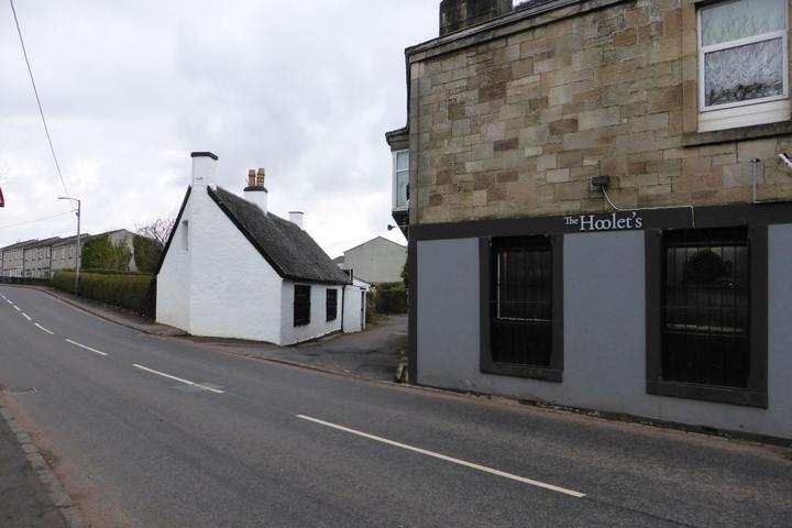
Pathfoot cottage and former hostelry

Farms, crafts and local services
A later directory snapshot provides named residents and occupations rather than a population total. Naismith’s 1878–79 Hamilton directory lists John M‘Murray at the Barhill Tavern, Alexander Jackson at Barnhill Farm, and James Templeton as a blacksmith at Barnhill. It also places Brown’s nursery at the locality’s road junction in the later local-history account, although that identification is not independently verified by the directory entry. The names suggest a rural community with farming, smithing and a public house, while the surrounding parish had already become closely connected to mining, railways and manufacturing. A single directory cannot establish how representative these trades were or how long each business operated. naismith hamilton directory 1878 79 blantyre Churches, schools and societies in Blantyre in 1879
The local-history account describes Barnhill as having farms, thatched cottages, handloom weavers, a nursery and a smithy. It reports families associated with Milheugh, Bardykes and other properties, and places a former dry-green near Barnhill buildings. These details are useful leads into census, valuation-roll and estate records, but the article’s claims about individual family ownership and the exact vanished buildings require independent records. blantyre project origins barnhill
Routes, topography and changing streetscape
The village stands close to the wooded valley of the Rotten Calder, which has shaped both settlement and movement west from Blantyre. The local account proposes that an older route from Glasgow once passed from Loanend and Malcolmwood Farm through Barnhill and crossed the Calder at Pattonholm Ford before ascending the slope called the Peth. It distinguishes that hypothesised route from a later crossing and road at the foot of Peth Brae. The route reconstruction is an interpretation; no medieval road plan or archaeological survey is cited, and the sequence should be tested against estate plans and historic OS mapping.
The same account says the first-edition OS six-inch sheet surveyed in 1864 depicts 24 roofed and two partly roofed buildings at Barnhill. NRS catalogue reference RHP89523 is a c.1864 1:2,500 plan marked to show superiors and feuars in Stonefield, Springwell and Auchinraith; it may help contextualise landholding and nearby settlement, but neither this plan nor the cited six-inch map has been inspected for this article. A later NRS record, RHP95126, identifies an 1898 25.344-inch OS sheet XI.15. These catalogue entries are map leads, not substitutes for reading the sheets. historical maps nrs blantyre parish maps and plans
The local account attributes road straightening and widening to 1929 and says some building gables were cut back. It also notes that cottages gradually disappeared and modern houses replaced the rural settlement. The change is plausible within the wider growth of road traffic but needs comparison of dated OS sheets, road-authority records and photographs before the exact work and affected properties can be established.
Barnhill and the Calder landscape today
South Lanarkshire Council declared the Greenhall, Milheugh and Barnhill Local Nature Reserve on 27 January 2022. The council describes open parkland with mature trees, woodland on the valley sides, fields and nearby housing, with the Rotten Calder forming part of the site’s natural boundary. The declared reserve is a modern managed landscape and does not define Barnhill’s historic extent. Its management records provide a route to study the valley’s estates, paths, biodiversity and community use; any historic boundary must be reconstructed from period sources. Greenhall, Milheugh and Barnhill Local Nature Reserve Council declaration
Related
- High Blantyre
- Springwell, Blantyre
- Greenhall, Milheugh and Barnhill Local Nature Reserve
- The historical parish of Blantyre
- Historical maps of Blantyre
- Samuel Lewis, Topographical Dictionary of Scotland: Blantyre (1846)
- Naismith’s Hamilton Directory, 1878–79: Blantyre entries